
Week 6: 52 Ancestors 52 Weeks
On your family history travels have you ever wondered where exactly people were living and what their world may have looked like? Maps help us to understand distances between places, where people lived and where they may have traveled to. Following is a pictorial journey around the Thanet Region of Kent.

In 1842 on October 30 Jane LAWRENCE married Edward Waller LOADES in the St Pancras Church, Camden. At the time of her marriage she was living in Wood Street and Edward was living in Cromer Street. They were married in Saint Pancras Old Church, Saint Pancras Road [3].
Jane was not born in Middlesex or London. The 1851 Census tells us that she was born in Saint Nicholas at Wade in Kent [5], from the marriage certificate we know that her father was a farmer and was named William. This information meant we were able to find her baptism record in Saint Nicholas at Wade, Kent, England on November 26, 1820 [6].

Having researched the LAWRENCE family I decided that I would spend a day in the Thanet region and visit the churches where members of the LAWRENCE family had married, died or been baptised. Using my trusted google maps I plotted out a route that I would use. I had made sure to hire a care with GPS as I was traveling by myself and knew I would need to concentrate on the roads and where I was going. In theory this was a good idea, unfortunately I couldn’t work out how to use it so relied on my phone. What I didn’t consider is that country road while sealed are often very narrow and only provide room for one vehicle, this does impact how you drive and is not something that as an Australian driver we are use to, our roads are wide, even if they are not always sealed. Using the phone was a good idea, but I forgot to change to the kilometres to miles on the phone which made the “in one kilometre you will arrive at you destination” not so easy to work out. It would probably be easier with a navigator, but still an experience I would not have missed. So where did I go?

The map above highlights the places visited all were places of importance to the LAWRENCE and FRIEND family. While some of the burial grounds wee searched, there were no headstones remaining for any o the key people in the family. The LAWRENCE and FRIEND descendants were agricultural labourers and it is unlikely that funds were available within the family to mark their burial spots.


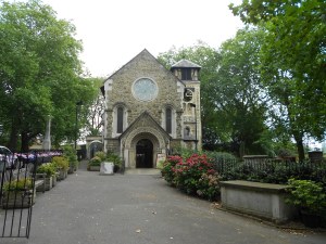
[9] Images of churches taken in the Kent – Goodnestone, Littlebourne, Minster and St Margaret At Cliffe, taken by the author
Maps can provide us with lots of information even when viewing them through the computer and in out lounge room. But nothing beats following up the e-viewing with an in person visit if we can.
Happy travels.
- Feature image: Creative Commons Attribution 4.0 international. Map of the City of London. Welcome MOO12961.jpg : https://wellcomeimages.org/indexplus/obf_images/89/0e/942b776d52156ab8465916fe05c0.jpg accessed February 13, 2022.
- South East England Counties Map. https://upload.wikimedia.org/wikipedia/commons/6/68/South_East_England_counties_2009_map.svg : accessed February 13, 2022.
- Marriage Parish Record. England, Saint Pancras, Middlesex. October 30, 1841. LOADES, Edward Waller and LAWRENCE, Jane. London, England, Marriages and Banns, 1754 – 1921. London Metropolitan Archives, Saint Pancras Church, Register of Marriages, P90/PAN1, Item 081. http://www.Ancestry.com.au : accessed February 13, 2022.
- Image: Saint Pancras Old Church, Saint Pancras Road. Personal image of the author.
- Census. England, Clerkenwell, Middlesex. LOADES, Jane. 1851 Census. Database Online. Class: HO107; Piece: 1516; Folio: 249; Page: 15; GSU roll: 87850. http://www.ancestry.com.au : accessed February 13, 2022.
- Baptism Parish Record. England, St Nicholas at Wade. November 26, 1820. LAWRENCE Jane. Canterbury Cathedral Archives, Kent Baptisms, St Nicholas at wade 1813 – 1844, Archive Reference U3/18/1/4. https://www.findmypast.com.au : accessed February 13, 2022.
- Image: Saint Nicholas at Wade Church, Kent. Personal image of the Author.
- Map of Kent that highlights visit made.
- Images of churches taken in the Kent – Goodnestone, Littlebourne, Minster and St Margaret At Cliffe, taken by the author


How fun to take a trip like that. I think I might be terrified to drive around the U.K. But what amazing old churches and cemeteries to see.
LikeLike
Your church trip sounds like fun, even if it is challenging to navigate the narrow lanes in the UK. Thanks for sharing.
LikeLike